
Walpole Previous Residents by Era
The backward trail of a Walpole address is a layered timeline, not a single list of former households. Start with the current situs address and parcel identifier, then label each finding with a record date, the person named, that person’s role, and the address wording used at the time. A deed names parties to a recorded instrument. A valuation list supplies assessment context. A directory may show a person, landmark, village, or boarding clue. Keeping these categories separate makes it possible to explain what supports a former-owner inference and what supports only historical presence.
| Source | Years It Covers | Where Held | What It Shows |
|---|---|---|---|
| Norfolk recorded-land index and images | 1793-present | Norfolk Registry and online research | Conveyance parties, instrument, book/page, date, legal description, image |
| Registered Land / Land Court | System from 1901; indexes from 1973 | Norfolk Registry separate system | Registered title, certificates, encumbrances, and plans |
| Walpole valuation and tax material | 1852, 1854, 1870, 1876, 1887, 1892; every fifth year 1895-1960 | Walpole Library and Historical Society | Assessment, owner, and tax context by era |
| Resident and business directories | 1884 through 1918 located runs | Walpole Room and Internet Archive | Name, street or landmark, village, role, boarder or host wording |
| Street lists | 1923, 1924, 1927, 1928, 1931, 1932-2023 | Walpole Room and Historical Society | Historical civic street-list context |
| Census and local newspapers | Census 1790, 1810, 1830, 1850; newspapers 1874-2021 | Walpole Room and NewsBank route | Household snapshots, notices, events, and date clues |
| Vital and cemetery sources | Local compiled and index runs; cemetery project | Library, Town Clerk, State Archives, RVRS | Family-event or burial context, subject to access rules |
| Atlases, maps, and Sanborn material | 1876 atlas, 1904 context, later local maps | Library, Historical Society, Library of Congress | Street, landmark, footprint, boundary, and parcel context |
Use the source closest to the question’s date, then work outward. A title question normally begins with the Registry. A household question often begins with the nearest directory or street list. A location question may begin with an atlas or map. No one of those sources establishes every relationship attached to an old address.
Walpole Previous Residents Start With a Parcel
A current parcel is the anchor, not the answer. Walpole’s assessor database provides an address, owner snapshot, and MBLU, the local term also used for a parcel identifier. MassGIS can add parcel geometry, land valuation, use, and abutter context. Record the source access date and fiscal-year label with that starting information. The assessor’s FY2027 ownership date is January 1, 2026, so a later deed does not necessarily appear on that tax snapshot. An owner name also should never be restated as an occupant name.
Save the situs wording exactly, along with map, lot, and sub fields when the assessor record uses them. Look for a legal-description clue in the recent deed after the parcel search. That description, rather than a street number alone, is often what carries the same tract backward through changed maps and early indexes. The MassGIS map is a useful geographic layer, but Registry material and a survey govern legal title and boundary questions.
- MBLU
- Walpole’s parcel identifier, also described by the assessor as Parcel ID. It links the assessor record to the situs parcel.
- Situs address
- The location of the parcel. It may differ from a mailing address and does not identify every person connected to it.
- Legal description
- The deed’s land description, often using boundaries, plans, or other terms that can survive when old address indexing fails.
Walpole Deed Chain for Past Residents
The Norfolk County Registry of Deeds holds recorded-land indexes and images described from 1793 forward. Its online research route separates recorded land from the Registered Land or Land Court system, which was established in 1901 and has indexes beginning in 1973. Check both systems when a recorded-land search stops unexpectedly. The Registry’s records identify parties to instruments and the parcel trail; they do not show that every named grantor, grantee, trust, or estate occupied the house.
The Norfolk deed-index research portal is the starting point for the grantor, grantee, address, plan, book, and page fields.
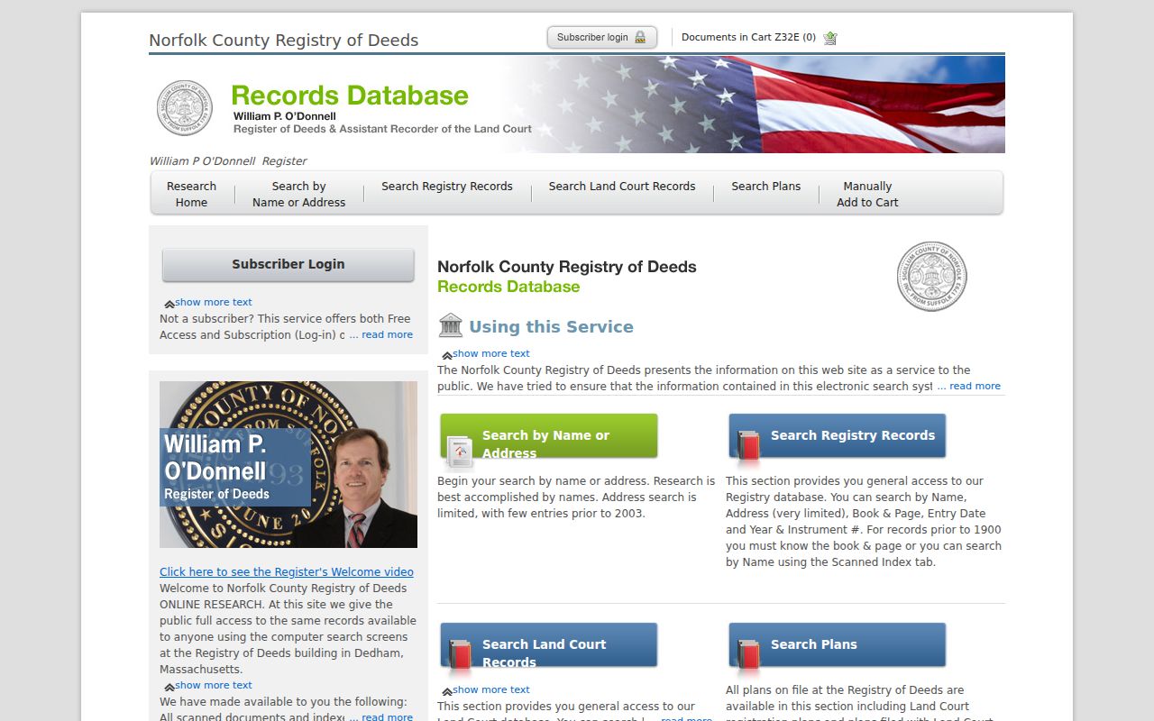
Use the index to locate the instrument, then preserve both deed date and recording date because they can differ.
- Capture the current Walpole situs address, MBLU, owner field, and any visible map or lot reference from the assessor or GIS record.
- Search the recent grantee or address in the Registry, then note instrument type, parties, deed date, recording date, book/page, document reference, and legal description.
- Search the seller as grantee to find the earlier purchase, then repeat with the prior party and the same parcel description.
- When a person appears as an estate, trust, or entity, search the recorded role and instrument type rather than one exact full-name phrase.
- Keep a dated chain with source links and page references. Stop when the description no longer supports the same parcel or when a separate registered-land search is required.
- Grantor
- The party transferring an interest in the recorded instrument.
- Grantee
- The party receiving that recorded interest. Searching the prior grantee is a key backward step.
- Chain of title
- A sequence of recorded instruments tied by parties, book/page references, and legal description. It is not a list of all residents.
Walpole Previous Residents Before Address Indexing
Registry address searching is strongest for applicable documents since 2003 and is very limited before then. An empty address result for an older Walpole property is therefore an indexing constraint, not evidence that no prior deed exists. The Registry guide directs older work toward the known owner, grantor or grantee, legal description, plan, book/page, and historical name indexes. Names are searched last name first, and a wildcard can help where spelling varies. Narrow a countywide result by town, document type, or date range.
Older deed research follows a manual pattern: grantee index to book and page, deed date, then grantor index to move backward. Plans can be searched by book/page, plan number and year, street name, owner name, or surveyor. Free online images carry a notice that they are not official copies. The Dedham Registry remains the in-person fallback when an old image, registered-land question, or index gap cannot be resolved online; mail and phone requests work best with a book/page or document number.
Note: Address absence in a historical Registry search should lead to legal-description and party research, not a claim that a property had no earlier owners.
Walpole Previous Residents in Historic Maps
Maps help translate the place wording in a directory into historic geography. Walpole sources include the 1876 Norfolk County atlas, 1904 atlas boundaries, local early-map material, and a five-sheet 1904 Walpole Sanborn map at the Library of Congress. The Sanborn resource is a link-only source here because no usable project image was captured. It can show a building footprint or nearby feature for the sheet’s date, not a list of people living there.
Compare “near Willet,” “cor. Kendall,” East Walpole, and South Walpole wording from the 1884 directory with a map from the right period. Then use a later numbered street list, plan, or deed description to test a modern-street candidate. Walpole’s boundary history matters too: prior land connections involved Dedham, Foxborough, and Sharon, so an older record may use a neighboring locality. Preserve the historical label instead of forcing it into a current address.
Walpole Previous Residents in Household Sources
Ownership is only one layer of a house history. Walpole’s resident and business directory runs cover 1884, 1884-85, 1886, 1886-87, 1893, 1897, 1900, 1906, 1909, 1911, 1916, and 1918. They can attach a name to a street, a landmark, a village, a recorded role, or a host. The 1884 collection is particularly useful because it has resident, street, and business sections. Its boarder notation must remain a boarder notation, not an ownership conclusion.
The 1884 Walpole directory scan supplies a dated human-use layer for a property trail.

Pair the printed wording with a page reference, map context, and a nearby edition instead of translating it directly into a modern address.
Walpole Room census material includes 1790, 1810, 1830, and 1850. These are household and demographic snapshots with their own enumeration date and geography. Pair the nearest available city directory or street list with the census year, then use newspapers, vital indexes, or cemetery records for event context. The historical volumes themselves are detailed in the Walpole city-directory collections.
Walpole Previous Residents in Street Lists
The library’s street-list holdings bridge the period after the located directory editions. They include 1923, 1924, 1927, 1928, 1931, and 1932-2023, with known gaps. The collection describes them as lists of persons age 17 and older. A street-list entry adds civic address context for its edition, but it is not a complete proof of every household member and should retain its date and source label.
Valuation materials bring another view of the same address. Walpole holds entries for 1852, 1854, 1870, 1876, 1887, 1892, and every five years from 1895 through 1960. They can indicate assessment or owner context during an era, while maps and directory entries speak to place wording or historical presence. Joining them creates a fuller evidence timeline without blending the roles together.
Walpole Previous Residents and Record Roles
A strong Walpole address timeline has one row per source event: source name, edition or record date, access date, person named, role, address wording, and a short note on what the source supports. Label a Registry party as grantor or grantee. Label an assessor result as owner as of its fiscal-year snapshot. Label a directory result as a historical listing, boarder, host, or business reference. Label a cemetery or obituary item as family-event context. Those distinctions prevent a name match from becoming a claim about who lived there.
The Walpole Room at 143 School Street is the best local route when the online chain ends. Its directories, valuations, newspapers, maps, census material, and vital indexes can be requested through reference@walpole.ocln.org or 508-660-7340. The Walpole Historical Society at 33 West Street holds documents, records, photographs, and memoirs that can identify a landmark or local institution. Neither repository should be asked to disclose protected information or to reconstruct a living person’s address.
Note: Keep the source, role, and date beside every name so a past-resident lead never becomes an unsupported present-tense statement.